Theta may record as Equirectangular Panorama Image
The spherical image data taken by the theta is stored as 3584x1792-sized-rectangle JPG files. If you provide any 3584x1792-sized-rectangle JPG images to a theta viewer, RICOH THETA for windows(R)/Mac, you canOnce we transform the spherical image data to 3584x1792-sized-rectangle JPG format, we can share any spherical image data with the site of the theta360.com. The forward and the inverse mapping from XY-coordinate on the rectangle JPG image to latitude/longitude on the spherical image data are required for this transformation.
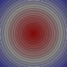
I generated border test chart which has 16-pixel-height borders as shown:

You can see this border test chart with the online theta viewer:
From this simple test, the theta may record as the equirectangular panorama image. The relationship between the XY-coordinate and the latitude/longitude might be:
(No guarantee, of course)
where
The latitude at the equator is zero [deg], the north is positive, and the south is negative.